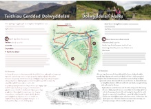
- Parking & start:
- Roadside parking by Rhiw Fachno, grid ref: SH753472
- Distance:
- 5km / 3 miles, allow 2-2.5hrs
- Grade:
- Moderate – rough track with steady climb to Rhiw Bach
The Route
1. Go over stile beside gate and follow clear track that bears left then climb steadily up the track alongside the old quarry. Spoil heaps and the remains of water channels, sheds and mill ruins can be seen. The slates and spoil were moved in trucks and the stone slopes are inclines built to safely bring the loaded trucks down the steep hillside. At the top of each incline was a large drum around which a long metal cable was wound. The cable was attached to the trucks and was slowly unwound allowing the trucks to move down. As a loaded truck descended its weight pulled up an empty truck. The finished slates were taken by steam engine to Betws-y-coed station for distribution. Follow the track as it winds up the hillside, still climbing steadily. Go through a gate onto open moorland and continue on path with the river on the left. Notice the stonewall of the old earth dam that once held water to power the quarry machinery.
2. Go through a gate into the forest and follow path back onto open moorland. Here the path forks leading to different parts of Rhiw Bach Quarry. The left-hand fork leads round to the derelict quarry village, firstly passing the remains of low cottages with pigsties and old slate fences and then the main village with larger barracks and houses. The main path bears right and then climbs steeply up to the mill, whose tall chimney is clearly visible. At Rhiw Bach most of the quarrying took place underground creating huge caverns where slate blocks were extracted. The blocks were cut with saws in the sheds and then split into thin roofing slates at the mill. The finished slates were hoisted up the incline behind the mill and taken on horse drawn trucks via a tramway to Blaenau Ffestiniog to join the railway to Porthmadog.
3. From Rhiw Bach mill retrace your steps back down to the start.
Walking Advice
Brief route directions are given but it is essential that you also take an OS 1:25000 Explorer map, as few routes are fully waymarked. Routes that cross the moorland need particular care and good map-reading skills.
Please follow the country code and make sure you keep dogs under control, particularly near livestock.
Rough distances are given in the routes directions. As a guide allow 15 kilometers per kilometer walking at an easy pace on the flat but allow an extra ascent(roughly 1 minute per 10m of ascent). Overall timings for the walk are s are generous, allowing time for stops.
Equipment
Walks require walking shoes and warterproof clothing and always take food and water. Some routes through the forest and moor can be very boggy.
Please be aware that this booklet was made in early 2008 and many of the routes are in a working forest and paths may inevitably change. If you know of any changes that have taken place to these routes or would like to add any extra information regarding these routes please contact mentersiabod@directsave.net
Copies of the booklet are available to purchase from the Community Pavilion and Siop y Llan Dolwyddelan, The Eagles Penmachno, Shell Garage and Tourist Information Centre Betws-y-Coed. Please note that all funds raised are put back into footpath maintenance in Penmachno and Dolwyddelan. For more information contact mentersiabod@directsave.net
This post is also available in: Welsh